Orlando weather, forecast
and current conditions --
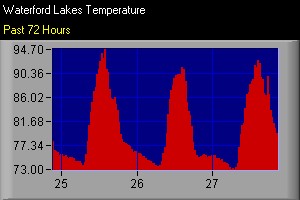
plus Waterford Lakes
weather conditions from
our private weather
station -- updated every
10 minutes.
Information
last updated at 9/27/11 8:35pm
Orlando
Weather 5-Day Forecast
Tue
Wed
Thu
Fri
Sat
T-storms
Chance T-storms
Chance T-storms
T-storms
Clear
91°
92°
90°
90°
86°
74°
74°
72°
70°
65°
Orlando
Weather Current Conditions
Waterford
Lakes Weather/
Clear
Temperature: 79.4°
Wind:
0 mph
Barometer:
29.90 Steady
Direction:
S
Humidity:
89%
Gust:
0 mph
Dew
Point:
75.9o
From
Waterford Lakes private
weather station, updated
at 9/27/11 8:35pm
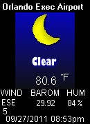
Orlando
Weather/
Broken Clouds
Temperature: 80.6°
Wind:
4 mph
Barometer:
29.92
Direction:
ESE
Humidity:
84%
Gust:
4 mph
Dew
Point:
75.2o
From
Orlando International
Airport, updated at 09/27/2011 08:53pm